Anyone searching for a single day out that combines a mountain funicular, real alpine views, a cave system, and a boat ride usually finds these attractions scattered across separate listicles, each treated as its own outing. In practice, they line up into one continuous route around the northern side of Lake Thun, starting high on the Niederhorn and finishing back at lake level. This guide walks through the day in the order it actually happens on the ground: how to get to the starting point, what each stop looks like, how long to budget, and the logistics that make or break the day, like funicular timetables and the last boat back.
The route works equally well as a day trip from Thun or from Interlaken, and if you’re deciding which of the two towns to base yourself in for a longer Bernese Oberland trip, it’s worth reading alongside a general Thun travel guide, since Thun sits at the opposite end of the lake from Beatenberg and is the natural starting or ending point for this route by train and boat. If you have another day in the region, Oeschinensee is one of the most spectacular alpine lakes in the Bernese Oberland.
Why This Route Works as a Day Trip
The appeal of pairing Niederhorn with Lake Thun is that it covers three completely different types of scenery in a single day without much backtracking: high alpine panorama, forested hillside, and lake shoreline. Most visitors either do the mountain half (funicular and summit) or the lake half (caves and boat) as isolated activities, missing that Beatenberg sits directly between the two. Treating the whole thing as one loop, mountain down to lake, means the transitions between sections (funicular to trail, trail to shoreline path, shoreline to cave, cave to boat dock) become part of the day rather than separate outings requiring separate trips back to a hotel.
It also means the day trip works from either end of the lake. Coming from Thun, the boat ride out in the morning and the funicular in the afternoon can be reversed, ending the day back at the caves and dock rather than starting there. Coming from Interlaken, the bus to Beatenberg is usually the quicker option, saving the boat for the return leg at the end of the day.
Getting to the Niederhorn Funicular
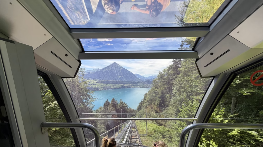
The starting point is Beatenberg, a hillside village above the northern shore of Lake Thun, sitting roughly opposite Thun itself across the water and a short bus ride up from Interlaken. There are two common ways to reach it: a direct postbus from Interlaken Ost, or the Beatenberg funicular from Beatenbucht at the lakeshore, which is itself reachable by boat from Thun or Interlaken. Travelers basing themselves in Thun for the wider region will find that connection by boat particularly convenient, since it turns the first leg of the day into part of the scenery rather than a transfer to get through.
From Beatenberg, the Niederhorn funicular (“Niederhornbahn”) climbs the final stretch to the summit station. A same-day return ticket, sold as the Niederhorn Sommer Tageskarte, covers the ride up and back and is the simplest option if the plan is a there-and-back trip rather than a longer traverse toward the Justistal or the Sigriswil ridge. Because the funicular runs on a fixed schedule rather than continuously, checking departure times before setting off from the lake is worth doing, especially outside the main summer months when frequency drops and gaps between cars can stretch well past half an hour.
Riding the Niederhorn Panoramic Gondola
The gondola itself is open-sided, built for the view rather than shelter, and the ride up is where the trip starts to earn its reputation. The car climbs past red-roofed chalets scattered across the hillside, with Lake Thun’s turquoise water dropping away below and the pyramid silhouette of the Niesen visible across the valley. This stretch is short, but it’s the first clear sense of scale for the day: the lake, the ridgelines, and the beginning of the higher Bernese peaks in the distance.
Because the cabins are open to the air, weather matters more here than in an enclosed cable car. A clear morning gives the best visibility for the Eiger-Mönch-Jungfrau skyline later at the summit, so checking a mountain-specific forecast rather than a general town forecast for Thun or Interlaken is worth the extra step before committing to the ride.
Views From the Niederhorn Summit

At the top, the terrain opens into a wide viewpoint over the Bernese Alps. On a clear day, the snow-capped ridge across the valley includes the Eiger, Mönch, and Jungfrau group, one of the more recognizable skylines in the Bernese Oberland. The summit station building, marked with Swiss flags, sits right at this vantage point, making it an easy stop even for visitors who don’t plan to walk further.
For those who do want to move beyond the station, a short section of trail follows the limestone ridge nearby, generally in the direction of the Chüeweid or Burgfeld area. It’s not a technical hike, but the terrain along the ridge is rockier and more exposed than the manicured area right at the funicular exit, so proper shoes are worth having even for a short stretch. Hikers looking to extend the day further sometimes continue from this ridge toward the Augstmatthorn or down into the Justistal valley, though that turns the outing into a full hiking day rather than the shorter loop described here.
The Descent and a Detour Toward Beatenberg
The ride back down retraces the same line, with the lake and the Niesen back in view, this time from the opposite angle and with the funicular’s own cable and track visible in the foreground. It’s a good moment for photos looking back down the mountain rather than up at it, and the lighting is often different from the morning ascent, especially if the day trip started early and this leg happens closer to midday.
Rather than heading straight back to a car or bus stop, a worthwhile detour is a wooden viewing platform on the hillside near Beatenberg, marked with a carved tree-trunk totem known locally as “Flimbo.” The platform looks directly out over the lake, and depending on the season, waterfalls cascading down the rock face behind it add another layer to the scene. It’s a quieter stop than the summit and easy to miss if it isn’t specifically on the plan, since it sits slightly off the main path down from the funicular station.
Walking the Lake Thun Shoreline
From the hillside, the route drops down toward the water itself. The shoreline path here runs through trees with the lake’s bright turquoise color showing through gaps in the foliage, and it’s common to see one of the small local ferries passing by on the water. This stretch is mostly flat and functions as the connector between the hillside viewpoints and the lakeside attractions below, specifically the caves, and it’s a reasonable place to stop for lunch before the second half of the day begins.
Anyone approaching from the Thun side of the lake instead of Beatenberg will meet this same shoreline path from the opposite direction, making the caves a natural midpoint where the two versions of the route (starting from Beatenberg versus starting from Thun) converge.
Exploring the St. Beatus Caves

The St. Beatus Caves (Beatushöhlen) sit directly on Lake Thun’s shore and are one of the more unusual stops on this route because of what greets visitors before they even reach the entrance. A waterfall drops straight down the limestone cliff face just outside the cave mouth, fed by the underground stream that carved the caves themselves, and the path up to the entrance runs right alongside it. The microclimate this creates is pronounced enough that palm trees grow near the entrance, an unexpected sight this deep into the Alps and a detail that surprises most first-time visitors who associate this landscape purely with pine forest and limestone.
The Legend Behind the Name
The caves take their name from Beatus, a figure tied to local legend as the first Christian missionary said to have settled in the region, supposedly living in the caves themselves after driving out a dragon that had made its home there. Whether or not any of that history holds up to scrutiny, the story has stuck to the site for long enough that it shows up in the name of the caves, the surrounding trail signage, and most local retellings of the area’s history. It’s the kind of background detail that adds context to the visit without needing to be verified as fact, and it explains why a cave system on a Swiss lake carries a saint’s name in the first place.
Inside the Grand Tour Route

Once inside, marked walkways lead past stalactites, flowstone formations, and the underground stream that continues to shape the cave system today. The standard visitor route, sold as the “Grand Tour,” covers roughly half a kilometer of the cave interior and is built specifically for general visitors rather than cavers, meaning the walkways are paved, lit, and railed rather than requiring any scrambling or specialized equipment. This is the version of the caves most day-trippers experience, and it’s substantial enough to feel like a real underground excursion without turning into a technical caving trip.
For visitors who want to go further, guided tours sometimes run deeper into the unlit sections of the system, reserved for those specifically booking a caving-style experience rather than the standard walk-through. That’s a separate booking and a separate kind of visit entirely, worth knowing about in advance if the goal is something more adventurous than the paved Grand Tour path.
What to Expect Physically
The caves stay cool and often noticeably damp year-round, regardless of how warm it is outside on the lakeshore, so a light layer is worth carrying even in the middle of summer. The temperature difference between the sun-exposed approach path and the cave interior is sharp enough that it’s easy to underestimate, especially after walking the lakeshore path or descending from Beatenberg in full sun beforehand. The walkways themselves are well maintained but can be uneven and slightly slick in spots where water seeps through the rock, so footwear with decent grip matters more here than almost anywhere else on this route.
Reaching the Caves Without the Rest of the Day
Visitors coming specifically for the caves and skipping the mountain portion of the day entirely can reach this stop directly by boat from Thun or Interlaken, without needing the funicular, the ridge walk, or the Beatenberg detour at all. This makes the caves one of the more accessible lake attractions in the region, well suited to travelers with only half a day to spare, families with young children who might not manage the full Niederhorn route, or anyone visiting Lake Thun primarily for the boat trip itself and treating the caves as a single scenic stop along the way rather than the midpoint of a longer day.
Ending the Day With a Lake Thun Cruise

The final stop is the ferry dock near the caves, where the Lake Thun boat schedule determines the return option. A classic white lake steamer typically handles this route, and boarding here for a return trip toward Thun or Interlaken is a low-effort way to close out the day while still taking in the water and shoreline from a different vantage point than the morning’s mountain views. Checking the current year’s timetable before arriving at the dock avoids a longer-than-necessary wait, since sailings are less frequent outside the main summer season.
For those ending the day in Thun rather than Interlaken, the boat ride back doubles as an approach into the old town from the water, arriving near the same waterfront covered in more detail in the dedicated guide to Thun, which is worth reading if the plan includes an evening or overnight stay there rather than an immediate return to Interlaken.
How Long the Full Day Trip Takes
Budgeting the day realistically matters more here than on a single-attraction outing, since it strings together transit, a funicular, a short walk, a cave tour, and a boat ride. A comfortable pace, from first funicular departure to last boat back, generally fills a full day rather than a half day, roughly eight to nine hours door to door once travel from Thun or Interlaken on both ends is included. Trying to compress it into a half day usually means cutting either the ridge walk at the summit or the time spent at the caves, both of which are worth keeping if this is a one-time visit to the region.
Best Time of Year for This Route
The Niederhorn funicular and the boat services both run on reduced or seasonal schedules outside the main summer window, so timing affects nearly every leg of this itinerary. Late spring through early autumn is when all the pieces, funicular, ridge trail, and boat timetable, tend to run at full frequency, which matters most for anyone trying to string the whole day together without long waits between connections. Outside that window, it’s worth confirming which services are running before building the day around all of them, since a shoulder-season visit might mean swapping the boat return for a bus back to Beatenberg or Thun instead.
What to Pack
Layers matter more on this route than the temperature in Thun or Interlaken that morning would suggest. The summit is noticeably colder and windier than the lakeshore, the open-air funicular offers no shelter from wind on the way up, and the caves add their own cool, damp environment partway through the day. Footwear suited to uneven limestone terrain is useful for anyone doing even the short ridge section near the top station, and a printed or saved copy of the boat timetable removes the guesswork at the end of the day when energy, and phone battery, tends to be lower.
Where to Base Yourself for This Trip
Thun and Interlaken are the two obvious bases for this route, and the choice mostly comes down to which end of the lake is more convenient for the rest of a trip. Thun offers a quieter old town and direct boat access to the caves and Beatenberg without needing to change transport, which suits travelers who want the lake itself to be part of the daily routine rather than just a day-trip backdrop. The full breakdown of what Thun offers as a base, including its old town and lake access, is covered in the separate Thun Switzerland guide. Interlaken, by contrast, is the more common base for onward trips into the Jungfrau region and has more frequent transport connections overall, which can make the bus to Beatenberg quicker than the boat option from Thun.
Authors


Get My Personal Travel Maps




Leave a Reply