We arrived at the Kandersteg cable car station at 11:50 on a Saturday and the parking lot was already completely full. That alone tells you something about how popular this lake is. So we changed plans on the spot, drove down to Blausee first, and then caught the postbus back up to Kandersteg from the Blausee stop. On weekends that bus runs once an hour, always at 41 minutes past the hour, so if you time it right you barely lose any time at all. It turned a parking headache into an easy detour and honestly a better morning than if we had just circled the Kandersteg lot waiting for a spot.
Oeschinensee sits above Kandersteg in the canton of Bern, at the foot of the Blüemlisalp massif, and it is one of the most photographed alpine lakes in the country for good reason. It also happens to be one of the most touristy spots in Switzerland, and on the day we went, the overwhelming majority of the people around us were foreign visitors rather than locals, which is worth knowing going in so you can set your expectations for crowds accordingly. What follows is everything I picked up planning this trip and actually being there, from the geology under your feet to the exact rules posted at the trailhead.
How Oeschinensee Actually Formed
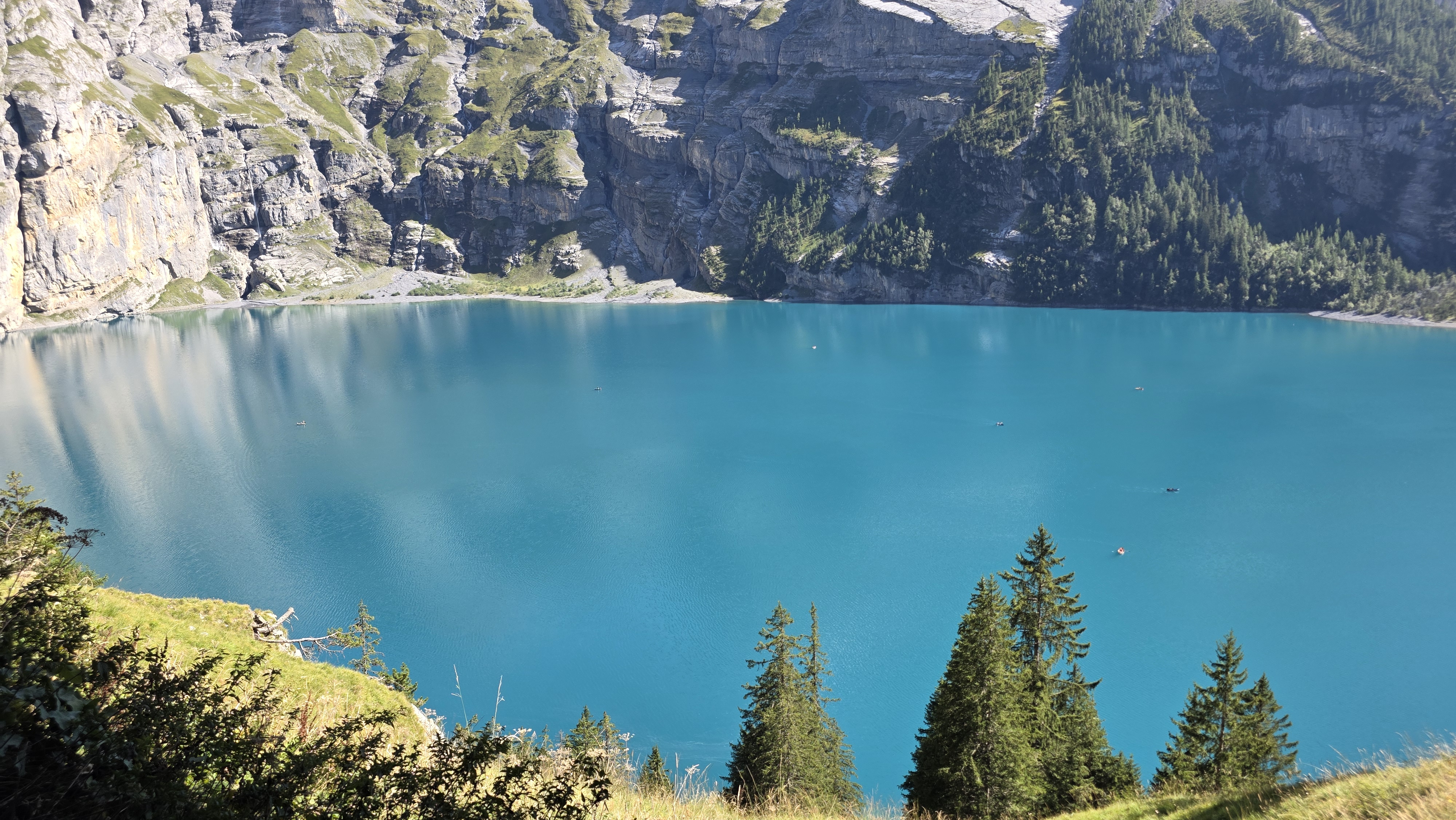
The lake sits in a natural bowl at the foot of the Doldenhorn, Fründenhorn, and Blüemlisalp, and it exists because of a genuinely massive prehistoric rockslide. A huge volume of rock and debris, geologists estimate well over a hundred million cubic meters of it, broke away from the mountainside and slid down into the valley, forming a natural dam that blocked the meltwater draining out through the Öschibach. Behind that dam, the water backed up and filled the basin, creating the lake you see today. Because the rock debris that forms the dam is porous, the lake still has no real surface outlet even now, and instead drains slowly downward through the rock itself, which is part of why the water level and clarity behave a little differently from a normal glacial lake.
Exactly when this happened is genuinely still debated among geologists. Some research points to a rock avalanche as recently as around 2,300 years ago, possibly triggered by an earthquake, while other accounts tie the lake’s origin to the same much older ice-age landslide event, roughly 15,000 years ago, that also created Blausee further down the valley. I am not going to pretend to settle a geological argument that professional researchers are still working through, but either way, you are standing on the debris of one of the larger rockslides in the Bernese Alps every time you walk the shoreline.
A Little History
Tourism found this lake early. In 1892, a local named David Wandfluh set up a simple coffee house with a hay loft for overnight guests right at the lakeside, serving hikers and taking them out for boat rides across the water. That original operation grew into the Berghotel Oeschinensee, which is still run today by the fifth generation of the same Wandfluh family, a piece of continuity that I find genuinely charming given how much the place has changed around it. Since 2007, the lake and the surrounding area have been part of the Swiss Alps Jungfrau-Aletsch UNESCO World Heritage Site, official recognition of a landscape that people were already flocking to more than a century earlier.
Getting Up There
If you do manage to snag a parking spot at the valley station in Kandersteg, pricing is straightforward: four hours costs 5 francs, and a full eight hours costs 10 francs. You can pay by Twint or with cash at the machine, so you are not stuck if your card or phone app of choice does not work that day. From the valley station, the gondola lifts you most of the way up, and from the top station you can either walk down to the lake in around twenty to thirty minutes on the easy path, or do what we did and hike the whole way up from Kandersteg on foot.
One thing worth checking before you go, especially if you are visiting in peak summer: during the busiest stretch of the season, roughly from late June to late September, the cable car operator has introduced mandatory time slot reservations in addition to a valid ticket, precisely because demand has gotten so high. A ticket bought through a third-party app does not automatically come with a boarding slot, so check the current booking rules on the official site before you build your day around a specific arrival time.
Walking up from Kandersteg to Oeschinensee took us about one hour and twenty minutes at a comfortable pace, gaining a real amount of elevation along the way. If you are reasonably fit and used to mountain trails, you can shave a decent chunk off that time. It is a proper uphill walk rather than a stroll, so budget accordingly and bring water, but it means you arrive at the lake having actually earned the view rather than just stepping out of a cable car.
How Long to Actually Spend There
Give yourself at least two hours at the lake itself once you arrive. That is not an exaggeration to pad out your itinerary, it is genuinely the minimum for doing the place justice. Between walking a stretch of the shoreline, finding a spot to sit with the view, maybe getting in the water if it is warm enough, and grabbing something to eat at one of the mountain restaurants, two hours disappears fast. If you also want to do the mountain coaster, rent a boat, or hike further into the valley, plan for closer to half a day.
Water Temperature by Month and When to Actually Swim

Oeschinensee is fed by snowmelt and waterfalls coming down off the surrounding peaks, so it runs cold for most of the year and only becomes genuinely swimmable for a short window in summer. Here is roughly what to expect month by month, based on typical seasonal patterns for the lake.
| Month | Typical Water Temperature | Good for Swimming? |
|---|---|---|
| January | Frozen or near 0°C | No, lake often iced over |
| February | Frozen or near 0°C | No, lake often iced over |
| March | Near 0-4°C, ice melting | No |
| April | 4-8°C | No, far too cold |
| May | 8-11°C | Not really, only for the very brave |
| June | 11-15°C | Marginal, refreshing dip at best |
| July | 16-20°C | Yes, this is when it gets good |
| August | 18-20°C, occasionally warmer | Yes, the best month to swim |
| September | 13-16°C | Borderline, still doable on a hot day |
| October | 8-11°C | No, too cold for most people |
| November | Near 0-4°C | No |
| December | Frozen or near 0°C | No, sometimes used for ice skating |
If swimming is the actual goal of your trip, late July through August is your window, ideally on a stretch of sunny days so the surface water has had time to warm up. The simple pebble beaches along the western shore, near the mountain restaurants, are the spots people actually swim from. There is no infrastructure like changing huts or showers, so come prepared to change in the open or bring a towel wrap.
Renting a Boat and Fishing on the Lake
Unlike Blausee, where the only way onto the water is a short guided ride, Oeschinensee lets you rent your own rowing boat and go out under your own power. Boat hire runs by the hour at 40 francs per boat, payable in cash or by card, and the rental operates roughly from early May through late October, weather permitting; strong wind, fog, or a foehn storm will shut it down for safety. A full lap of the lake by rowing boat takes a good hour depending on your fitness and how much the wind is fighting you, and doing it gives you a completely different perspective on the surrounding three-thousand-meter peaks than you get from the shore. Life jackets are mandatory for children under twelve and for anyone who cannot swim.
If fishing is more your thing, dedicated fishing boats are also available, equipped with a fish box and an anchor, for a day rate of around 100 francs, though you will need to bring your own rod, hooks, and bait since none of that is provided. Day and week fishing permits are sold at the restaurants on site, and fishing here falls under the canton of Bern’s mountain lake fishing regulations, so it is worth checking the current rules before you plan a serious session. Given the limited number of boats available, reserving ahead is a good idea in high season.
Where to Eat
There are a few small mountain establishments clustered at the western end of the lake, and eating here is part of the experience rather than an afterthought. The Berghotel Oeschinensee, run by the Wandfluh family since that first 1892 coffee house, offers a proper restaurant with a terrace looking straight down the lake toward the Blüemlisalp. Nearby, the Berghaus and the Sennhütte cover more casual meals, and Chalet Arva rounds out the options with its own hotel and restaurant. None of them are going to surprise you with anything experimental, this is honest mountain food, but a plate of rösti or a bowl of soup with that view in front of you is exactly what you want after the hike up.
Hiking Beyond the Lake
Most visitors do the shoreline walk and call it a day, and that is a completely valid way to enjoy Oeschinensee. But if you have more time and legs left in you, the trails continuing past the lake are genuinely worth knowing about. Paths lead up toward the alp huts at Unterbergli and Oberbergli on the north side, climbing above the lake for a different angle on the whole basin, and from there more serious hikers continue toward the Hohtürli pass and the Blüemlisalphütte, a proper high-mountain hike rather than a lakeside stroll. These routes demand real fitness, good boots, and an early start, but they turn a half-day excursion into a full alpine day out for anyone who wants it.
Wild Cows and How to Behave Around Them
This caught a few people in our group off guard: the trail and the pastures around Oeschinensee are genuinely used for grazing, and it is completely normal to round a bend and find cows standing on or right next to the path. They are calm animals used to hikers, but they are still large, unpredictable livestock, not park decorations. Keep a real distance, do not walk in between a cow and her calf if you see one, and never try to touch, pet, or feed them, however friendly they look. If a cow is blocking a narrow section of trail, the right move is to wait calmly and give it space to move on its own rather than trying to squeeze past or shoo it out of the way.
The Best Viewpoint, and It Is an Easy One

You do not need to hike far to get the view that makes Oeschinensee famous. A short walk from the gondola’s top station, there is a bench along the trail that gives what I can only call a ten out of ten view straight down the length of the lake toward the Blüemlisalp glacier. It is an easy, flat walk to reach, suitable for pretty much anyone, and it is where most of the classic photos of this lake actually get taken. If your time or mobility is limited, making it to this one bench and back is still absolutely worth the trip.
The Mountain Coaster
Right next to the top gondola station is the Oeschinensee mountain coaster, officially called the Rodelbahn Oeschinensee, a 750-meter alpine slide that drops about 150 meters in height as you ride a small cart down a winding metal track, controlling your own speed with a simple brake lever. It is genuinely fun for kids and adults alike, and tickets are sold individually or in bundles of five for a better price. My honest tip here: because this spot is so heavily visited, your speed on the ride is largely dictated by whoever is in the cart ahead of you, and on a busy day that can mean a fairly gentle ride rather than a fast one. If what you actually want is a proper fast alpine coaster experience, you will have a much better time doing one of the similar rides in a less touristy part of Switzerland where the queues are shorter and nobody is riding the brakes in front of you the whole way down.
A Current Safety Note: Rockfall Above the Lake
This is worth knowing before you plan your route around the lake. The slope known as Spitze Stei, above Kandersteg and near the south shore of Oeschinensee, has been geologically unstable for years, with authorities monitoring increasing movement that experts link partly to permafrost thawing at altitude. Parts of the south shore and nearby trails have been closed at various points since 2020 due to this risk, and conditions worsened further during heavy rainfall in the summer of 2025, which triggered debris flow and led to additional trail closures in the area. None of this should scare you off visiting, thousands of people still do every week, but it does mean the exact trail network around the lake can change season to season. Check current trail status through the official Kandersteg-Oeschinensee tourism channels before you set out, rather than relying on an old map or a blog post, including this one, for the precise route.
All the Rules, in One Table
Oeschinensee sits inside the Jungfrau-Aletsch UNESCO World Heritage area, and there is a clearly posted set of outdoor guidelines at the trailhead covering exactly what is and is not allowed. Here is the full list as posted, so you know before you go rather than finding out from a ranger on site.

| Rule | What It Means |
|---|---|
| Littering | Collect your own rubbish and use the official bins at the stations, restaurants, and along the main trails |
| Dogs | Dogs must be kept on a leash at all times, and especially in wildlife rest zones and during grazing season |
| Distance to animals | Keep a safe distance from all animals; observing is fine, feeding or touching is not |
| Toilets | Use the public toilets at the cable car stations and the mountain lodge by the lake; going in nature is discouraged everywhere in the area |
| Hiking | Stay on the official, marked hiking trails and plan your route, gear, and timing before you set out |
| Wildlife reserves and protected areas | Entering wildlife rest zones, plant protection zones, and closed-off areas is prohibited |
| Camping and bivouacking | Wild camping, overnighting in hammocks, and bivouacking anywhere in the open are legally forbidden |
| Bikes | Cycling of any kind, including mountain bikes and e-bikes, is banned throughout the Oeschinensee area by legal order |
| Fire in the open air | Only light fires at the official designated barbecue spots, due to forest fire risk |
| Drones | Flying drones or any model aircraft anywhere in the Oeschinensee area is banned by legal order |
None of these are unusual for an alpine nature area, but the bike ban and the drone ban in particular seem to catch a lot of visitors by surprise, so it is worth knowing both before you plan your day.
Getting There and Making a Day of It
The easiest route is by train to Kandersteg, which sits on the well-connected Bernese Oberland rail line, followed by either the gondola up to Oeschinensee or the uphill hike if you have the time and legs for it. If you are driving and the Kandersteg lot is full, as ours was, do not panic: heading down to Blausee first and catching the hourly weekend postbus back up, as we did, turns a wasted morning into an easy two-stop day. Given how close the two lakes are, doing both Blausee and Oeschinensee in a single day trip out of the Kandertal is a genuinely great way to spend a summer day in the Bernese Oberland, one calm and enclosed, the other big, wild, and framed by glaciers.
If you want to plan the wider trip around it, our Blausee guide covers the smaller, calmer lake just down the valley, and our Switzerland travel guide is a good starting point for the rest of the country. If you are basing yourself in the region, our Thun guide covers the closest proper town with a train connection into the Kandertal, and our day trip to Niederhorn and Lake Thun is a solid option if you have a second day to fill in the same region.
Author

Get My Personal Travel Maps
Keep Reading: More Articles You'll Love
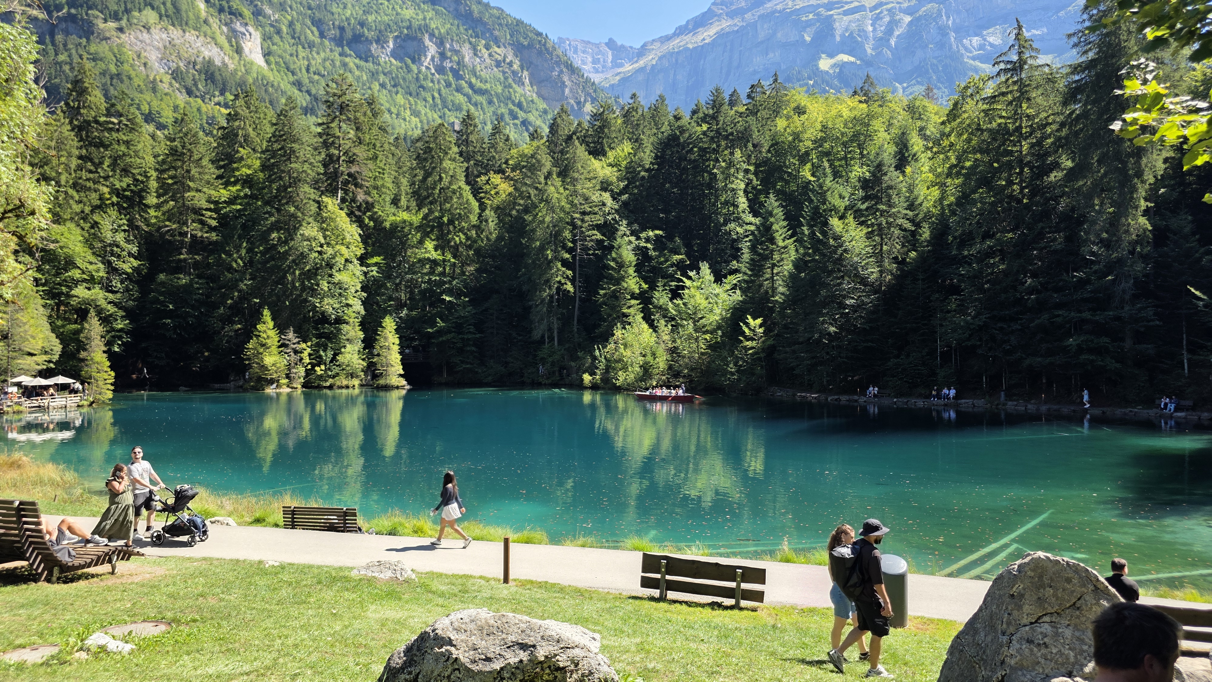 Blausee Switzerland: My Complete Guide
  A Guide to Niederhorn, Beatenberg and the Caves of Lake Thun
  Lake Kawaguchiko Itinerary: Best Mt. Fuji Views & Hidden Gems
  Thun, Switzerland: Castle, Aare Surfing, Riverside Food and How Long to Stay
  Hiking to Heidi’s Alp Above Maienfeld: The Real Village Behind the Story
  Sokcho & Seoraksan: A Swiss Guide to Hiking, Buddhas, and Buckwheat
  Neuchâtel, Switzerland: The Complete Travel Guide to the Lake, the Castle, and the Chocolate Town